
Southern Utah
Top 8 Things To See.

“Utah Rocks”
Southern Utah my God where do I even start? You’re just so damn pretty. You’re so damn impressive. Everything is so damn big in this state. My eyeballs are almost too tired & over stimulated by your beauty. The canyons are soooo large, that some canyons have their own canyons inside of other canyons. The mountains are so damn tall. The mesas are so damn grand. I could just keep going on and on and on because I’m seriously impressed, and happily overwhelmed Utah.
OK, I guess as with most things it’s best to start at the beginning.

Monument Valley
I had just spent the previous week trippin around northern Arizona and finished up in Sedona. Monument Valley is only a 3 1/2 hour drive from Sedona, so that’s where I headed next. Monument Valley sits on the Arizona Utah State line and it also lies within the Navajo Nation territory. Monument Valley has been on my bucket list for years, and as the Valley’s vivid red colors of the sandstone buttes came into view, I got a little teary-eyed. This area of the world is not easy to get to you, it's rather out of the way, so knowing that I had actually made it here was slightly overwhelming for a brief moment. Due to COVID the 17 mile loop road into Monument Valley itself is closed, though from our hotel room at Goulding’s we had a fabulous view of this majestic site.


Let me share the accommodations at Goulding’s with you because this place is pretty damn cool. The room was basic, clean and the staff were all very nice. It has a swimming pool, museum, restaurant, but it’s the setting that is outstanding. The hotel itself is backed up to a huge sandstone rock, so that the hotel looks like it’s actually part of the rock. Then there’s the view…… from our own private balcony we had an unspoiled view of Monument Valley. We watched as the sun went down and toasted with champagne. The perfect evening.

The next morning we left Goulding’s shortly after sunrise and as we were driving along Hwy 163 we came to one of the most iconic views of Monument Valley, the road from the movie Forest Gump. I believed that this popular view was part of the 17 mile loop inside the park that was closed. I was delighted to discover I hadn’t missed it.

Forest Gump Hill

Mexican Hat
Fun Fact. This tiny town has a population of 31. I couldn’t wait to pass through this town because I’m Mexican and I just love the name Mexican Hat. Who wouldn’t want to pass through a town named Mexican Hat? On the northeast side of town sits a rock formation that resembles a sombrero hat and that’s how the town got its name.


Not a great pic, but you can understand the town’s name.
Valley of the Gods
What do you call a place that’s north of Monument Valley, with similar formations, reddish brown mesas and mushroom looking rocks? You call it Valley of the Gods of course.

The only way to truly see all of Valley of the Gods is on a 17 mile drive on a gravel road that winds itself around large stunning formations of sandstone. This gravel road is maintained but it does have some steep and bumpy areas. I believe it’s probably passable by non 4-wheel drive vehicles but I wouldn’t suggest it. The Bureau of Land Management runs this area, that means there are no fees and no services. Dispersed camping is allowed but campfires here are not. This place is gorgeous and beside the dirt road, it seems untouched. Make plans and see for yourself why this area is named Valley of the Gods.


Valley of the Gods

Valley of the Gods, the background looks like a water color painting.
Natural Bridges National Monument
Established in 1908, Natural Bridges is Utah’s first National Monument. There are three bridges to view here (Kachina, Owachimo & Sipapu) and each bridge has its own hike. The nice thing about this area is you have a few different choices in which you can see all three bridges. If hiking really isn’t your thing you can simply view each bridge from its own viewing platform. If hiking is your thing, then there is a 9.8 mile loop that connects all three bridges. If 9.8 miles is too long of a hike, each bridge has its own individual hike you can take.
TIP - Take more water than you think you’ll need. Remember you’re in the desert, sunscreen is your friend.

Kochina Bridge

Owachimo Bridge

Sipapu Bridge
Side Note After a long day of driving and hiking we arrived at our next hotel to find out that it had overbooked itself and we had no place to sleep for the night. The only other hotel close didn't have a vacancy. Don’t forget, this is a remote area and it will be dark soon. Advice, don’t drive around mountainous Utah at night, you could drive right off a cliff easily.
Gahhhhh……..made a conscious decision on the spot to make lemonade out of this fucking huge basket of lemons. Long story short, had a Lara Bar for dinner, parked next to camp trailers & RVs in a dispersed camping area. The wind was blowing HARD, had no choice but to sleep inside of the truck(Tacoma). Not the best night's sleep.
Capitol Reef National Park

On an overcast day the colors intensify.
Whoa, Capitol Reef National Park is sensational. This park was named Capitol Reef because it has so many white domes made of Navajo sandstone over red sandstone cliffs. These white domes resemble the domes of the US and other “capital” buildings.

Cassidy Arch
I like this park because there’s just so much to do and see here, petroglyphs, bridges, 7.9 mile scenic drive, stunning rock formations, fruit trees, hikes, and so much more that I didn’t get to take a look at. I only explored the Fruita area of Capitol Reef, and here there are no fees to explore this portion of the park.

Petroglyphs

Hickman Bridge

The Fluted Wall

The Fluted Wall

Sunset color is the best!

Fruita Barn

Capitol Reef Scenic Drive

TIPS
Avoid canyons and washes when storms threaten. This is a flash flood area.
FOOD
The Wild Rabbit Cafe in Torrey. Breakfast is served all day, love that! Good coffee, the best coffee of the entire trip. Fresh bakery, love that too!


Highway 12, Boulder to Escalante
I have read in many different places that this stretch of Scenic Hwy 12 between Boulder and Escalante is the most beautiful paved road in all of Utah. The highway at some points treads narrow ledges with sheer cliffs on either side, and has switchbacks with intense grades. This area also has some spectacular dirt road drives with unique less traveled points of interest.

Hwy 12-Burr Trail - This road is a 66 mile link between Boulder and Bullfrog, today I’m not traveling all 66 miles I’m more interested in what awaits around mile 11. Approximately 11 miles down the Burr Trail you’ll get to an area where you can park on the left-hand side of the road. There are no signs marking the spot but you can see a clearly traveled walking path with an easily reachable slot canyon. The locals call this place “Singing Canyon” because the acoustics are said to be good here. I had the entire place to myself, so I sang a song loud and proud. Yes, the acoustics are tremendous.

“Singing Canyon”


At the end of “Singing Canyon”
Hell’s Backbone Road - Starting from the Boulder side, and I am proud to say that I have traveled the entire 44 one-way miles of this gravel road. Hell's Backbone Road was completed in 1933 allowing automobile traffic between Escalante and Boulder for the first time. Today, on this road, I never saw one other car. You can feel so small sometimes out in the wilderness.

Crossing Hell’s Backbone bridge with Death-Box Hallow wilderness in the background.
After a day full of driving & sightseeing, I was super stoked to be checking in to Wander Camp. This Wander Camp is outside the town of Tropic, and it has a bevy of 200 square foot waterproof canvas tents. Glamping……...I’m really glamping!! It’s such a cool thing I’ve always wanted to experience. This tent will be home base for the next few days and it’s furnished sparingly with such a plush feel. I love it!


FOOD
IDK Barbecue in Tropic
Stage Stop Station in Tropic

Bryce Canyon National Park
Heading out early the following morning and from our tent, it was only a short 20 minute drive to the entrance of this small but striking National Park. Bryce Canyon isn’t even a canyon, did you know that? I didn’t know until I read one of the many informational signs you can find throughout the park. Bryce is actually a collection of amphitheaters with gorgeous structures called hoodoos rising up from the bottoms. I have never seen a landscape like this before. I keep thinking damn Utah, how do you continue to blow my mind? Is it weird if I say, Utah you are so good-looking? Too bad if it is weird because, Utah, you are soooo good-looking.

Thor’s Hammer

Navajo Loop


Hiking up through “Wall Street”

Paria View

Inspiration Point
One full day was plenty of time for a hike on the Navajo Loop with Queen’s Garden and plenty of time to drive the entirety of the one main road while stopping at all the points of interest and overlooks. Bryce Canyon is breath taking, and the colors and natural architecture are mind blowing.
Kanab

So after spending the better part of a week out in the remote regions of Utah we arrived in the city of Kanab. Kanab sits north of the Arizona State line and it has a classic old western feel due to the city’s backdrop of Navajo sandstone cliffs. The city has been called “Little Hollywood” because so many western movies and TV shows have been filmed in and around Kanab. Most establishments have signed pictures of the celebrities who have passed through their doors.
So knowing that, Kanab does have some finer things with plenty of dining choices and a variety of places to stay.
I settled my last few days in Utah at the Canyons Lodge, rustic chic. I was totally content to just stay in the room or at the hotel pool but I fit in a few more hikes around this region before leaving Utah.


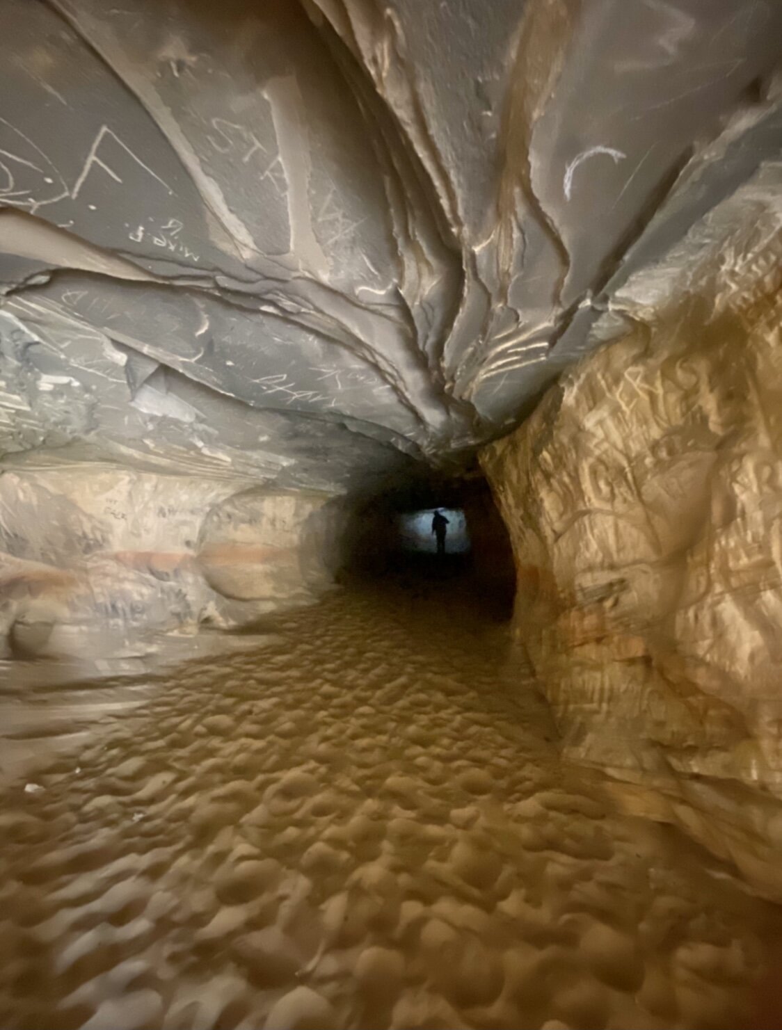
Kanab Caves
These caves are found on the north side of Kanab directly off Hwy 89. You will not find a trail maker sign nor will you find a designated trail to follow once you arrive. You will have to simply find your own safe way up and safe way down to enjoy these caves. I found that this hour of my time was well spent.


Toadstool Hoodoo Trail
45 miles east of Kanab, off of Hwy 89 you will come to Toadstool Hoodoo trail. This is an easy 1.8 mile out and back hike with a remarkable view a towering hoodoo. My picture below dose not covey how tall this rock formation is, so let me tell you, it’s truly tall.

Utah was more than I was expecting. The colors are more vibrant here. The rocks are so damn big in this state. The space is so vast. Remote wildernesses are all around you. You are constantly seeing something new and when you think you’re at the highest summit you realize there’s another summit that’s even higher. This was my first visit to this state but I can almost guarantee, I’ll be back to trip around some more.
Random Road Signs


